
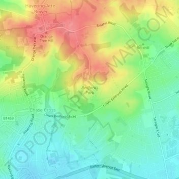
Bedfords Park topographic map
Interactive map
Click on the map to display elevation.
About this map
Name: Bedfords Park topographic map, elevation, terrain.
Average elevation: 62 m
Minimum elevation: 29 m
Maximum elevation: 109 m
Other topographic maps
Click on a map to view its topography, its elevation and its terrain.
Richmond Park
United Kingdom > England > London
Richmond Park, London Borough of Richmond upon Thames, London, Greater London, England, United Kingdom
Average elevation: 26 m
Fulham
United Kingdom > England > London
Fulham, London, Greater London, England, SW6 5HJ, United Kingdom
Average elevation: 17 m
Hampstead
United Kingdom > England > London
Hampstead, London, Greater London, England, NW3 1QG, United Kingdom
Average elevation: 57 m
Victoria Park
United Kingdom > England > London
Victoria Park, Fish Island, Old Ford, London Borough of Tower Hamlets, London, Greater London, England, United Kingdom
Average elevation: 13 m
London
United Kingdom > England > London
London, Greater London, England, SW1A 2DX, United Kingdom
Average elevation: 42 m
Farthing Street
United Kingdom > England > London > Farthing Street
Farthing Street, London Borough of Bromley, London, Greater London, England, BR6 7JB, United Kingdom
Average elevation: 131 m
London
United Kingdom > England > London
London Borough of Camden, London, Greater London, England, United Kingdom
Average elevation: 50 m
London
United Kingdom > England > London
London Borough of Newham, London, Greater London, England, United Kingdom
Average elevation: 8 m
Surrey
United Kingdom > England > London > Guildford
Surrey, Este Road, Clapham Junction, London Borough of Wandsworth, London, Greater London, England, SW11 2TB, United Kingdom
Average elevation: 69 m
London
United Kingdom > England > London
London Borough of Hammersmith and Fulham, London, Greater London, England, United Kingdom
Average elevation: 16 m
London
United Kingdom > England > London
London Borough of Lewisham, London, Greater London, England, United Kingdom
Average elevation: 33 m
Kensington
United Kingdom > England > London > Kensington
Kensington, London, Greater London, England, W8 6EA, United Kingdom
Average elevation: 19 m
Croydon
United Kingdom > England > London > Croydon
Croydon, London, Greater London, England, CR0 1SZ, United Kingdom
Average elevation: 70 m