
Make a donation
Gear up for your next adventure:
As an Amazon Associate, this site earns from qualifying purchases at no extra cost to you.
Naples topographic map
Click on the map to display elevation.
Make a donation
Gear up for your next adventure:
As an Amazon Associate, this site earns from qualifying purchases at no extra cost to you.
Naples
In 1755, the Duke of Noja commissioned an accurate topographic map of Naples, later known as the Map of the Duke of Nojo, employing rigorous surveying accuracy and becoming an important urban planning tool for Naples.
Make a donation
Gear up for your next adventure:
As an Amazon Associate, this site earns from qualifying purchases at no extra cost to you.
About this map
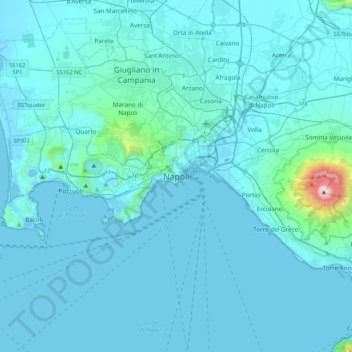
Name: Naples topographic map, elevation, terrain.
Location: Naples, Napoli, Campania, 80100, Italy (40.67588 14.08877 40.99588 14.40877)
Average elevation: 58 m
Minimum elevation: -3 m
Maximum elevation: 1,253 m
Make a donation
Gear up for your next adventure:
As an Amazon Associate, this site earns from qualifying purchases at no extra cost to you.