
Make a donation
Gear up for your next adventure:
As an Amazon Associate, this site earns from qualifying purchases at no extra cost to you.
Amiens topographic map
Click on the map to display elevation.
Make a donation
Gear up for your next adventure:
As an Amazon Associate, this site earns from qualifying purchases at no extra cost to you.
Amiens
The area of the commune is 4,946 hectares (12,220 acres); the altitude varies between 14 and 106 metres (46 and 348 ft).
Make a donation
Gear up for your next adventure:
As an Amazon Associate, this site earns from qualifying purchases at no extra cost to you.
About this map
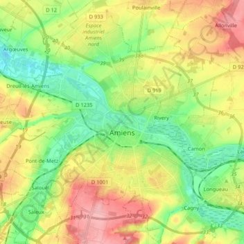
Name: Amiens topographic map, elevation, terrain.
Location: Amiens, Somme, Hauts-de-France, Metropolitan France, France (49.84684 2.22356 49.95055 2.34578)
Average elevation: 55 m
Minimum elevation: 9 m
Maximum elevation: 116 m
Make a donation
Gear up for your next adventure:
As an Amazon Associate, this site earns from qualifying purchases at no extra cost to you.
Other topographic maps
Click on a map to view its topography, its elevation and its terrain.
La Boisselle
France > Hauts-de-France > Somme > Ovillers-la-Boisselle > La Boisselle
Average elevation: 109 m
Make a donation
Gear up for your next adventure:
As an Amazon Associate, this site earns from qualifying purchases at no extra cost to you.
Beaumont-Hamel Newfoundland Memorial Park
France > Hauts-de-France > Somme > Beaumont-Hamel
Average elevation: 127 m