
Kent topographic map
Interactive map
Click on the map to display elevation.
About this map
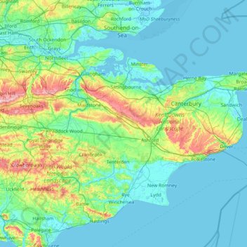
Name: Kent topographic map, elevation, terrain.
Location: Kent, England, United Kingdom (50.91048 0.03352 51.50368 1.45177)
Average elevation: 37 m
Minimum elevation: -3 m
Maximum elevation: 261 m
Kent was also the location of the largest number of art schools in the country during the nineteenth century, estimated by the art historian David Haste, to approach two hundred. This is believed to be the result of Kent being a front line county during the Napoleonic Wars. At this time, before the invention of photography, draughtsmen were used to draw maps and topographical representations of the fields of battle, and after the wars ended many of these settled permanently in the county in which they had been based. Once the idea of art schools had been established, even in small towns in Kent, the tradition continued, although most of the schools were very small one-man operations, each teaching a small number of daughters of the upper classes how to draw and make watercolour paintings. Nonetheless, some of these small art schools developed into much larger organisations, including Canterbury College of Art, founded by Thomas Sidney Cooper in 1868, which is today the University for the Creative Arts.
Other topographic maps
Click on a map to view its topography, its elevation and its terrain.
Weybridge
United Kingdom > England > Surrey > Elmbridge
Weybridge, Elmbridge, Surrey, England, KT13 8RT, United Kingdom
Average elevation: 21 m
West Lancashire
United Kingdom > England > Lancashire
West Lancashire, Lancashire, England, United Kingdom
Average elevation: 30 m
Stretford
United Kingdom > England > Trafford
Stretford, Trafford, Greater Manchester, England, M32 9DF, United Kingdom
Average elevation: 27 m
Trafford
Trafford, Greater Manchester, England, United Kingdom
Average elevation: 32 m
Cornwall
United Kingdom > England > Fairy Cross
Cornwall, Broadoak, Fairy Cross, Cornwall, South West England, England, United Kingdom
Average elevation: 49 m
High Wycombe
United Kingdom > England > Buckinghamshire
High Wycombe, Buckinghamshire, England, United Kingdom
Average elevation: 124 m
Malvern
United Kingdom > England > Worcestershire > Malvern Hills
Malvern, Malvern Hills, Worcestershire, England, WR14 2HX, United Kingdom
Average elevation: 95 m
Clarborough
United Kingdom > England > Nottinghamshire > Bassetlaw
Clarborough, Bassetlaw, Nottinghamshire, England, DN22 9LR, United Kingdom
Average elevation: 34 m
Worcester
United Kingdom > England > Worcestershire
Worcester, Worcestershire, England, United Kingdom
Average elevation: 38 m
Blackham
United Kingdom > England > East Sussex > Wealden
Blackham, Withyham, Wealden, East Sussex, England, TN3 9TT, United Kingdom
Average elevation: 72 m
Tibberton
United Kingdom > England > Worcestershire > Wychavon
Tibberton, Wychavon, Worcestershire, England, United Kingdom
Average elevation: 50 m
West Wycombe
United Kingdom > England > Buckinghamshire > West Wycombe
West Wycombe, Buckinghamshire, England, United Kingdom
Average elevation: 124 m
Chardstock
United Kingdom > England > Devon > East Devon
Chardstock, East Devon, Devon, England, United Kingdom
Average elevation: 132 m
London Borough of Tower Hamlets
United Kingdom > England > London
London Borough of Tower Hamlets, London, Greater London, England, United Kingdom
Average elevation: 9 m
Guisborough
United Kingdom > England > Redcar and Cleveland
Guisborough, Redcar and Cleveland, Tees Valley, England, United Kingdom
Average elevation: 147 m
River Yare
United Kingdom > England > Norfolk
River Yare, Norfolk, England, United Kingdom
Average elevation: 27 m
Reedham
United Kingdom > England > Norfolk > Broadland
Reedham, Broadland, Norfolk, England, United Kingdom
Average elevation: 4 m
Ingrave
United Kingdom > England > Essex > Brentwood
Ingrave, Brentwood, Essex, England, CM13 3QZ, United Kingdom
Average elevation: 76 m
High Peak
United Kingdom > England > Derbyshire
High Peak, Derbyshire, England, United Kingdom
Average elevation: 303 m
Woodford Halse
United Kingdom > England > West Northamptonshire
Woodford Halse, West Northamptonshire, England, NN11 3NS, United Kingdom
Average elevation: 154 m
Itchen Abbas
United Kingdom > England > Hampshire > Winchester
Itchen Abbas, Winchester, Hampshire, England, SO21 1DJ, United Kingdom
Average elevation: 81 m
Leedstown
United Kingdom > England > Cornwall
Leedstown, Cornwall, England, TR27 6DB, United Kingdom
Average elevation: 73 m
Crowborough
United Kingdom > England > East Sussex > Wealden
Crowborough, Wealden, East Sussex, England, United Kingdom
Average elevation: 146 m
Winchester
United Kingdom > England > Hampshire
Winchester, Hampshire, England, United Kingdom
Average elevation: 73 m
Compton
United Kingdom > England > West Sussex > Chichester
Compton, Chichester, West Sussex, England, United Kingdom
Average elevation: 105 m
Barton-upon-Humber
United Kingdom > England > North Lincolnshire
Barton-upon-Humber, North Lincolnshire, England, DN18 5QP, United Kingdom
Average elevation: 24 m
Painswick
United Kingdom > England > Gloucestershire
Painswick, Stroud, Gloucestershire, England, United Kingdom
Average elevation: 163 m
Skipton
United Kingdom > England > North Yorkshire
Skipton, North Yorkshire, England, United Kingdom
Average elevation: 173 m
Hathersage
United Kingdom > England > Derbyshire > Derbyshire Dales
Hathersage, Derbyshire Dales, Derbyshire, England, United Kingdom
Average elevation: 311 m
Runcorn
United Kingdom > England > Halton
Runcorn, Halton, Liverpool City Region, England, United Kingdom
Average elevation: 21 m
Tring
United Kingdom > England > Hertfordshire > Dacorum
Tring, Dacorum, Hertfordshire, England, United Kingdom
Average elevation: 168 m
Wimbledon
Wimbledon, Greater London, England, SW19 7NL, United Kingdom
Average elevation: 26 m
Birmingham
Birmingham, West Midlands Combined Authority, England, United Kingdom
Average elevation: 138 m
Wakefield
Wakefield, West Yorkshire, England, United Kingdom
Average elevation: 88 m
Ryhill
United Kingdom > England > Wakefield
Ryhill, Wakefield, West Yorkshire, England, United Kingdom
Average elevation: 76 m
West Lulworth
United Kingdom > England > Dorset
West Lulworth, Dorset, England, United Kingdom
Average elevation: 84 m
Swilla Glen
United Kingdom > England > North Yorkshire > Thornton in Lonsdale
Swilla Glen, Thornton in Lonsdale, North Yorkshire, England, LA6 3JJ, United Kingdom
Average elevation: 204 m
Swindon
United Kingdom > England > Swindon
Swindon, England, SN1 1LF, United Kingdom
Average elevation: 108 m
Ingleton
United Kingdom > England > North Yorkshire
Ingleton, North Yorkshire, England, United Kingdom
Average elevation: 309 m
Egham
United Kingdom > England > Surrey > Borough of Runnymede
Egham, Borough of Runnymede, Surrey, England, United Kingdom
Average elevation: 25 m
Bradford
Bradford, West Yorkshire, England, United Kingdom
Average elevation: 175 m
Charlbury
United Kingdom > England > Oxfordshire > West Oxfordshire > Charlbury
Charlbury, West Oxfordshire, Oxfordshire, England, United Kingdom
Average elevation: 132 m
Knole Park (Deer Park)
United Kingdom > England > Kent > Sevenoaks > Sevenoaks Weald
Knole Park (Deer Park), Sevenoaks Weald, Sevenoaks, Kent, England, United Kingdom
Average elevation: 161 m
Headley
United Kingdom > England > Surrey > Mole Valley
Headley, Mole Valley, Surrey, England, United Kingdom
Average elevation: 146 m
Bedgebury National Pinetum
United Kingdom > England > Kent > Tunbridge Wells > Kilndown
Bedgebury National Pinetum, Goudhurst, Kilndown, Tunbridge Wells, Kent, England, United Kingdom
Average elevation: 91 m
Richmond Park
United Kingdom > England > London
Richmond Park, London Borough of Richmond upon Thames, London, Greater London, England, United Kingdom
Average elevation: 26 m
Sevenoaks
United Kingdom > England > Sevenoaks
Sevenoaks, Kent, South East, England, United Kingdom
Average elevation: 96 m