
The Hague topographic map
Interactive map
Click on the map to display elevation.
About this map
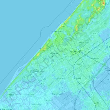
Name: The Hague topographic map, elevation, terrain.
Location: The Hague, South Holland, Netherlands (52.01485 4.18500 52.13504 4.42249)
Average elevation: 2 m
Minimum elevation: -6 m
Maximum elevation: 28 m
Other topographic maps
Click on a map to view its topography, its elevation and its terrain.
Zoetermeer
Netherlands > South Holland > Zoetermeer
Zoetermeer, South Holland, Netherlands
Average elevation: -3 m
Oud Ade
Oud Ade, Kaag en Braassem, South Holland, Netherlands
Average elevation: -2 m
Goeree-Overflakkee
Goeree-Overflakkee, South Holland, Netherlands
Average elevation: 0 m
Vredepolder
Netherlands > South Holland > Barendrecht
Vredepolder, Barendrecht, South Holland, Netherlands
Average elevation: 1 m
Krimpenerwaard
Netherlands > South Holland > Krimpenerwaard
Krimpenerwaard, South Holland, Netherlands
Average elevation: -1 m