
Make a donation
Gear up for your next adventure:
As an Amazon Associate, this site earns from qualifying purchases at no extra cost to you.
Galați topographic map
Click on the map to display elevation.
Make a donation
Gear up for your next adventure:
As an Amazon Associate, this site earns from qualifying purchases at no extra cost to you.
Galați
Galați is located in southeastern Romania. Its coordinates are latitude 45 ° 27 'north and longitude 28 ° 02' east. Its area is 246.4 square kilometers (95.1 sq mi). Galați lies in the southern part of the Moldavian Plateau on the left (west) bank of the Danube river at the junction of the Siret River (west) and the Prut River (east), near Lake Brates. It is 80 kilometers (50 mi) from the Black Sea. The nearest town is Brăila, 15 kilometers (9.3 mi) to the south. Galați is built on three geological terraces. One lies beneath "Valley City", with elevations between 5 and 7 metres (16 and 23 ft). The other two, which make a fan shape, have elevations of 20–25 meters (66–82 ft) (the site of the old town, now the city centre) and 40 meters (130 ft) (the site of the modern city) respectively. The Danube river is considered the "life-blood" of Galați. The Danube is the second longest river in Europe 2,850 km [ 1,770 mi ]), with an average flow of 6,199 cubic meters (218,900 cu ft) per second in the Galați section. After the Siret River, the largest tributary in Romania, joins the Danube, the flow is 210 cubic meters per second (7,400 cu ft/s). After the Prut River joins the Danube, the flow becomes 86 cubic meters per second (3,000 cu ft/s). The Danube river flows have significant seasonal variation. The maximum flows occur in May; 18,000–19,000 m3/s or 640,000–670,000 cu ft/s. The minimum flows occur during the summer; 2,000–2,450 m3/s or 71,000–87,000 cu ft/s.
Make a donation
Gear up for your next adventure:
As an Amazon Associate, this site earns from qualifying purchases at no extra cost to you.
About this map
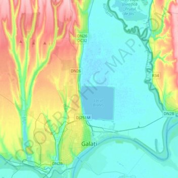
Name: Galați topographic map, elevation, terrain.
Location: Galați, Romania (45.39052 27.94336 45.61037 28.20869)
Average elevation: 39 m
Minimum elevation: -1 m
Maximum elevation: 140 m
Make a donation
Gear up for your next adventure:
As an Amazon Associate, this site earns from qualifying purchases at no extra cost to you.
Other topographic maps
Click on a map to view its topography, its elevation and its terrain.
Galați
Galați is located in southeastern Romania. Its coordinates are latitude 45 ° 27 'north and longitude 28 ° 02' east. Its area is 246.4 square kilometers (95.1 sq mi). Galați lies in the southern part of the Moldavian Plateau on the left (west) bank of the Danube river at the junction of the Siret River…
Average elevation: 33 m
Make a donation
Gear up for your next adventure:
As an Amazon Associate, this site earns from qualifying purchases at no extra cost to you.