
Make a donation
Gear up for your next adventure:
As an Amazon Associate, this site earns from qualifying purchases at no extra cost to you.
Fátima topographic map
Click on the map to display elevation.
Make a donation
Gear up for your next adventure:
As an Amazon Associate, this site earns from qualifying purchases at no extra cost to you.
Fátima
Fátima sits on a plateau at approximately 356 metres (1,168 ft) above sea level, being at a much higher altitude than the rest of the parishes in Ourém. This plateau represents the northernmost portion of the Estremadura Limestone Massif, which was created during the Middle Jurassic and is characterized by various geological formations including sinkholes, uvalas and polje (like the Polje de Minde-Mata), as well as karst grottoes, caves with stalactites and stalagmites, in addition to lapiez fields. As such, Fátima has geological and cultural similarities with the nature park of Serras de Aire e Candeeiros just south of it.
Make a donation
Gear up for your next adventure:
As an Amazon Associate, this site earns from qualifying purchases at no extra cost to you.
About this map
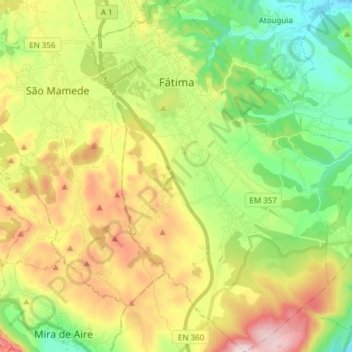
Name: Fátima topographic map, elevation, terrain.
Location: Fátima, Ourém, Santarém, Portugal (39.53582 -8.70225 39.65260 -8.58739)
Average elevation: 359 m
Minimum elevation: 145 m
Maximum elevation: 678 m
Make a donation
Gear up for your next adventure:
As an Amazon Associate, this site earns from qualifying purchases at no extra cost to you.
Other topographic maps
Click on a map to view its topography, its elevation and its terrain.