Geolocate

Slaley topographic map

Click on the map to display elevation.

About this map

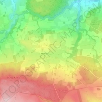
Name: Slaley topographic map, elevation, terrain.

Location: Slaley, Northumberland, North of Tyne, England, United Kingdom (54.88025 -2.10625 54.94252 -2.00054)

Average elevation: 210 m

Minimum elevation: 58 m

Maximum elevation: 383 m

Other topographic maps

Click on a map to view its topography, its elevation and its terrain.

Plenmeller

United Kingdom > England > Northumberland

Average elevation: 156 m

Gear up for your next adventure:

📊Altimeters & Barometers - Track elevation and weather changes
🥘Camping Cookware Sets - Cookware sets for backpacking meals
🧯Camp Safety Kits - All‑in‑one safety gear
🥣Outdoor Food & Meals - Dehydrated meals for backpacking
🗾Ireland Map Books - Top map books for exploring Ireland

As an Amazon Associate, this site earns from qualifying purchases at no extra cost to you.