Geolocate

Manchester topographic map

Click on the map to display elevation.

About this map

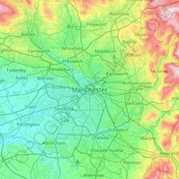
Name: Manchester topographic map, elevation, terrain.

Location: Manchester, Lancashire, England, M60 2UL, United Kingdom (53.31949 -2.40511 53.63949 -2.08511)

Average elevation: 118 m

Minimum elevation: 7 m

Maximum elevation: 486 m

Gear up for your next adventure:

🛌3-Season Sleeping Bags - Comfortable insulation for Irish spring and autumn nights
🔧Bicycle Repair Kits - On‑the‑go bike maintenance tools
📚Travel Books Ireland - Best travel books for Irish exploration
🍖Freeze-Dried Trail Meals - Nutritious and lightweight food for expeditions
💳Travel Cards for Ireland - Convenient payment abroad

As an Amazon Associate, this site earns from qualifying purchases at no extra cost to you.