
Bassano del Grappa topographic map
Interactive map
Click on the map to display elevation.
Bassano del Grappa
Rubbio is a frazione and quartiere located at an altitude of 1,057 m (3,468 ft) on the Asiago plateau. This hamlet is contiguous with another hamlet, also named Rubbio, which is part of the commune of Conco. Thus, in practice, the two hamlets form one village (named Rubbio), even though they belong to two different communes from the administrative point of view.
About this map
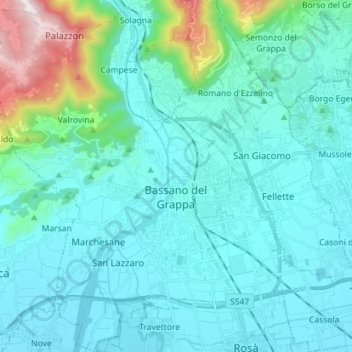
Name: Bassano del Grappa topographic map, elevation, terrain.
Location: Bassano del Grappa, Colceresa, Vicenza, Veneto, 36061, Italy (45.72317 11.64440 45.82212 11.76305)
Average elevation: 225 m
Minimum elevation: 79 m
Maximum elevation: 1,140 m
Other topographic maps
Click on a map to view its topography, its elevation and its terrain.
Monte Cengio
Italy > Veneto > Vicenza > Cogollo del Cengio
Monte Cengio is a mountain in the Asiago plateau, within the Vicentine Alps, in Veneto, northeastern Italy. It has an elevation of 1,354 metres and is located on the southwestern edge of the plateau, in the territory of Cogollo del Cengio.
Average elevation: 935 m