
Córdoba topographic map
Interactive map
Click on the map to display elevation.
Córdoba
Córdoba, located just north of the geographical center of the nation, is Argentina's fifth-largest province. The main feature of the province is the presence of an extensive plain covering the eastern two-thirds of the province and the existence of three major mountain ranges, which, combined, are known as Sierras de Córdoba: the easternmost range starts just west of the city of Córdoba and reaches altitudes of mostly around 1,000 meters (3,300 feet) in the southern portion and over 1,500 meters (4,900 feet) further north, with a maximum altitude of 1,950 meters (6,400 feet) at Cerro Uritorco. West of this chain, two valleys contain most of the tourist spots in the province: the Calamuchita valley in the south and the Punilla Valley in the north, home of scenic towns such as Villa Carlos Paz, Cosquín, La Cumbre, and La Falda.
About this map
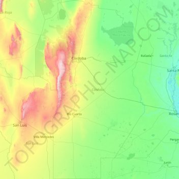
Name: Córdoba topographic map, elevation, terrain.
Location: Córdoba, Argentina (-35.01537 -65.77133 -29.50043 -61.77160)
Average elevation: 324 m
Minimum elevation: 3 m
Maximum elevation: 2,660 m
Other topographic maps
Click on a map to view its topography, its elevation and its terrain.