
Thank you for supporting this site ❤️
Make a donation
Make a donation
Gear up for your next adventure:
As an Amazon Associate, this site earns from qualifying purchases at no extra cost to you.
Eschenstruth topographic map
Click on the map to display elevation.
Thank you for supporting this site ❤️
Make a donation
Make a donation
Gear up for your next adventure:
As an Amazon Associate, this site earns from qualifying purchases at no extra cost to you.
About this map
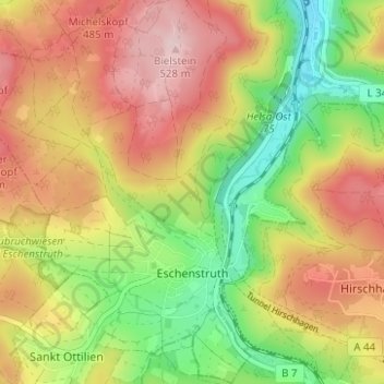
Name: Eschenstruth topographic map, elevation, terrain.
Location: Eschenstruth, Helsa, Landkreis Kassel, Hesse, Germany (51.21610 9.62381 51.25502 9.68513)
Average elevation: 403 m
Minimum elevation: 262 m
Maximum elevation: 541 m
Thank you for supporting this site ❤️
Make a donation
Make a donation
Gear up for your next adventure:
As an Amazon Associate, this site earns from qualifying purchases at no extra cost to you.