Geolocate

Li topographic map

Click on the map to display elevation.

About this map

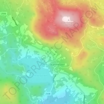
Name: Li topographic map, elevation, terrain.

Location: Li, Skammestein, Øystre Slidre, Innlandet, 2950, Norway (61.18280 8.95768 61.22280 8.99768)

Average elevation: 774 m

Minimum elevation: 589 m

Maximum elevation: 1,088 m

Gear up for your next adventure:

🧴Anti-Chafe Sticks - Prevent friction during long distance walking
🚨High-Decibel Whistles - Standard safety gear for mountain signaling
💧Portable Water Filters - Safe drinking water from streams and lakes
🍁Eco‑Friendly Outdoor Products - Sustainable outdoor gear
🧥Packable Down Jackets - High warmth-to-weight ratio for summit breaks

As an Amazon Associate, this site earns from qualifying purchases at no extra cost to you.