Geolocate

Stanmer topographic map

Click on the map to display elevation.

About this map
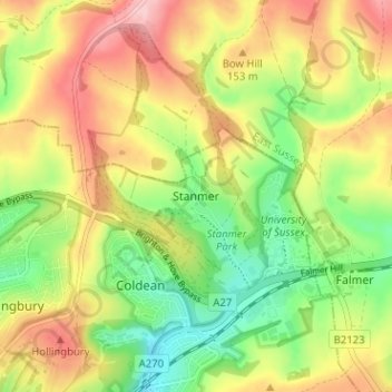
Name: Stanmer topographic map, elevation, terrain.

Location: Stanmer, Brighton and Hove, England, BN1 9PZ, United Kingdom (50.85099 -0.12195 50.89099 -0.08195)

Average elevation: 119 m

Minimum elevation: 38 m

Maximum elevation: 209 m

Other topographic maps

Click on a map to view its topography, its elevation and its terrain.
Brighton

United Kingdom > England > Brighton and Hove

Average elevation: 64 m

Hove Park

United Kingdom > England > Brighton and Hove > Hove

Average elevation: 53 m

Hove

United Kingdom > England > Brighton and Hove

Average elevation: 54 m

BN2 4PG

United Kingdom > England > Brighton and Hove > Brighton

Average elevation: 93 m

BN2 0QU

United Kingdom > England > Brighton and Hove > Brighton

Average elevation: 44 m

Gear up for your next adventure:

🧢Waterproof Caps - Keep rain off your face and glasses while hiking
🧯Campfire Safety Gear - Gear to safely manage fires
🧤Thermal Outdoor Gloves - Windproof and waterproof gloves for winter hiking
🧢Hiking Hats & Caps - Protective headwear for sun and rain
🪓Camping Hand Axes - For processing wood during forest camping

As an Amazon Associate, this site earns from qualifying purchases at no extra cost to you.