
Make a donation
Gear up for your next adventure:
As an Amazon Associate, this site earns from qualifying purchases at no extra cost to you.
Pontianak topographic map
Click on the map to display elevation.
Make a donation
Gear up for your next adventure:
As an Amazon Associate, this site earns from qualifying purchases at no extra cost to you.
Pontianak
Pontianak lies on the equator at a height ranging from 0.1 to 1.5 meters above sea level. It is divided into three parts by the Kapuas Besar and its major tributaries – the Kapuas Kecil and Landak rivers. The city lies on flat land in the delta of the Kapuas River with a ground level elevation ranging from 0.1 to 1.9 meters above sea level.
Make a donation
Gear up for your next adventure:
As an Amazon Associate, this site earns from qualifying purchases at no extra cost to you.
About this map
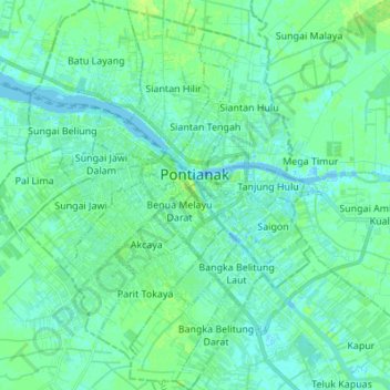
Name: Pontianak topographic map, elevation, terrain.
Location: Pontianak, West Kalimantan, Kalimantan, Indonesia (-0.09819 109.27417 0.03812 109.38535)
Average elevation: 4 m
Minimum elevation: -7 m
Maximum elevation: 9 m
Make a donation
Gear up for your next adventure:
As an Amazon Associate, this site earns from qualifying purchases at no extra cost to you.
Other topographic maps
Click on a map to view its topography, its elevation and its terrain.