
Make a donation
Gear up for your next adventure:
As an Amazon Associate, this site earns from qualifying purchases at no extra cost to you.
Oakton topographic map
Click on the map to display elevation.
Make a donation
Gear up for your next adventure:
As an Amazon Associate, this site earns from qualifying purchases at no extra cost to you.
About this map
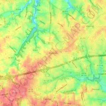
Name: Oakton topographic map, elevation, terrain.
Location: Oakton, Fairfax County, Virginia, 20030, United States (38.84107 -77.34085 38.92107 -77.26085)
Average elevation: 114 m
Minimum elevation: 73 m
Maximum elevation: 149 m
Make a donation
Gear up for your next adventure:
As an Amazon Associate, this site earns from qualifying purchases at no extra cost to you.
Other topographic maps
Click on a map to view its topography, its elevation and its terrain.
Lorton
United States > Virginia > Fairfax County
According to the United States Census Bureau, the Lorton CDP has a total area of 5.4 square miles (13.9 km2), of which 5.3 square miles (13.7 km2) is land and 0.1 square miles (0.2 km2), or 1.39%, is water. The elevation ranges from sea level at the Prince William County line (the Occoquan River) to slightly…
Average elevation: 41 m