
Thank you for supporting this site ❤️
Make a donation
Make a donation
Gear up for your next adventure:
As an Amazon Associate, this site earns from qualifying purchases at no extra cost to you.
Fuengirola topographic map
Click on the map to display elevation.
Thank you for supporting this site ❤️
Make a donation
Make a donation
Gear up for your next adventure:
As an Amazon Associate, this site earns from qualifying purchases at no extra cost to you.
About this map
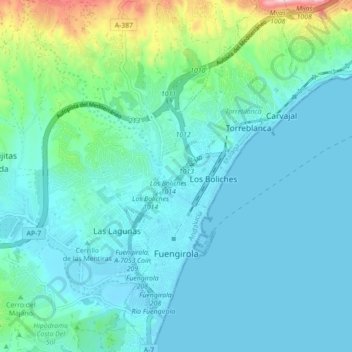
Name: Fuengirola topographic map, elevation, terrain.
Location: Fuengirola, Costa del Sol Occidental, Malaga, Andalusia, Spain (36.51902 -4.63662 36.58969 -4.58984)
Average elevation: 59 m
Minimum elevation: -1 m
Maximum elevation: 370 m
Thank you for supporting this site ❤️
Make a donation
Make a donation
Gear up for your next adventure:
As an Amazon Associate, this site earns from qualifying purchases at no extra cost to you.