
Make a donation
Gear up for your next adventure:
As an Amazon Associate, this site earns from qualifying purchases at no extra cost to you.
Conakry topographic map
Click on the map to display elevation.
Make a donation
Gear up for your next adventure:
As an Amazon Associate, this site earns from qualifying purchases at no extra cost to you.
About this map
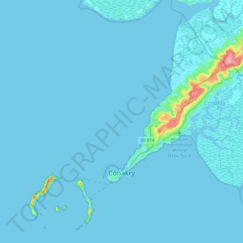
Name: Conakry topographic map, elevation, terrain.
Location: Conakry, Guinea (9.43219 -13.84029 9.75337 -13.47382)
Average elevation: 5 m
Minimum elevation: -1 m
Maximum elevation: 151 m
Make a donation
Gear up for your next adventure:
As an Amazon Associate, this site earns from qualifying purchases at no extra cost to you.
Other topographic maps
Click on a map to view its topography, its elevation and its terrain.
Mount Nimba Strict Nature Reserve
Guinea > Nzérékoré Region > Lola Prefecture
The Nimba Range has a sub-equatorial montane climate. Temperature changes extremely with altitude, with a daytime maximum ranging between 24 °C and 33 °C, and the nightly minimum can fall below 10 °C. Some parts of the reserve receive significantly less precipitation, due to rain-shadow effect of the high…
Average elevation: 657 m