
Magna topographic map
Click on the map to display elevation.
About this map
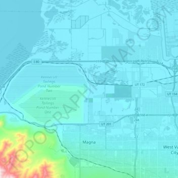
Name: Magna topographic map, elevation, terrain.
Location: Magna, Salt Lake County, Utah, United States (40.68183 -112.26022 40.81338 -112.06301)
Average elevation: 1,341 m
Minimum elevation: 1,275 m
Maximum elevation: 2,189 m
Other topographic maps
Click on a map to view its topography, its elevation and its terrain.
South Valence Drainage
United States > Utah > Salt Lake County > West Jordan
Average elevation: 1,388 m