
Make a donation
Gear up for your next adventure:
As an Amazon Associate, this site earns from qualifying purchases at no extra cost to you.
Zell am See topographic map
Click on the map to display elevation.
Make a donation
Gear up for your next adventure:
As an Amazon Associate, this site earns from qualifying purchases at no extra cost to you.
Zell am See
Zell am See provides winter skiing on the above Schmittenhöhe mountain. The skiable area is around 138 km, including the pistes on the Kitzsteinhorn and Kaprun Maiskogel. The ski pass covers the whole area including transport to and from the glacier, which is open most of the year, dependent on snowfall. Zell am See is a low-altitude ski area and snow cover can suffer from higher temperatures, but the glacier has snow cover most of the year.
Make a donation
Gear up for your next adventure:
As an Amazon Associate, this site earns from qualifying purchases at no extra cost to you.
About this map
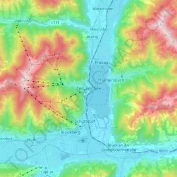
Name: Zell am See topographic map, elevation, terrain.
Location: Zell am See, Bezirk Zell am See, Salzburg, 5700, Austria (47.28200 12.73554 47.36532 12.89996)
Average elevation: 1,118 m
Minimum elevation: 742 m
Maximum elevation: 1,994 m
Make a donation
Gear up for your next adventure:
As an Amazon Associate, this site earns from qualifying purchases at no extra cost to you.