Geolocate

Bampton topographic map

Click on the map to display elevation.

About this map

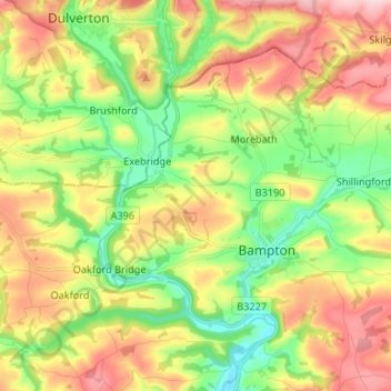
Name: Bampton topographic map, elevation, terrain.

Location: Bampton, Morebath, Mid Devon, Devon, England, United Kingdom (50.97307 -3.54310 51.03148 -3.41106)

Average elevation: 185 m

Minimum elevation: 82 m

Maximum elevation: 315 m

Gear up for your next adventure:

🥘Camping Cookware Sets - Cookware sets for backpacking meals
🚨Emergency Whistles - Safety whistles for hikers
🧣Multi-functional Neckwear - Protect against wind and sun with versatile Buffs
🔋Portable Power Banks - Keep devices charged on long trips
🏃‍♀️Running Hydration Belts - Hydration on the go for runners

As an Amazon Associate, this site earns from qualifying purchases at no extra cost to you.