Geolocate

Witham topographic map

Click on the map to display elevation.

About this map

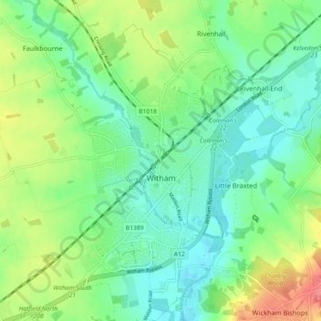
Name: Witham topographic map, elevation, terrain.

Location: Witham, Braintree, Essex, England, United Kingdom (51.77715 0.59342 51.83274 0.65834)

Average elevation: 36 m

Minimum elevation: 11 m

Maximum elevation: 87 m

Other topographic maps

Click on a map to view its topography, its elevation and its terrain.

Chipping Ongar

United Kingdom > England > Essex > Epping Forest

Average elevation: 68 m

Horkesley Heath

United Kingdom > England > Essex > Colchester

Average elevation: 50 m

Clacton-on-Sea

United Kingdom > England > Essex > Tendring

Average elevation: 7 m

Ingrave

United Kingdom > England > Essex > Brentwood

Average elevation: 76 m

Gear up for your next adventure:

🛡️Protective Bike Gear - Helmets & pads for safe rides
🪓Camping Axes & Hatchets - Wood cutting tools for campsite prep
⛷️Mountain Sports Accessories - Gear for high intensity outdoor sports
💧Portable Water Filters - Safe drinking water from streams and lakes
🔭Laser Distance Meters - Professional precision measuring for site surveys

As an Amazon Associate, this site earns from qualifying purchases at no extra cost to you.