

Ashburn topographic map
Click on the map to display elevation.
Ashburn
Ashburn is located in eastern Loudoun County at 39°02′37″N 077°29′15″W / 39.04361°N 77.48750°W / 39.04361; -77.48750 (39.0437192, −77.4874899) and its average elevation is 295 feet (90 m) above sea level. It is 7 miles (11 km) southeast of Leesburg, the county seat, and the same distance north of Dulles International Airport. As drawn by the U.S. Census Bureau, the area counted as "Ashburn" extends north to Virginia State Route 7, east to Virginia State Route 28, and southwest to the Dulles Greenway (VA 267). The Ashburn CDP is bordered to the north by the Belmont, Lansdowne, One Loudoun, and University Center CDPs; to the east by the Kincora, Dulles Town Center, and Sterling CDPs; to the southwest by the Moorefield and Broadlands CDPs; and to the west by the Goose Creek Village CDP.
About this map
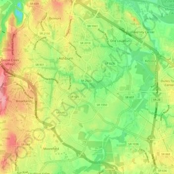
Name: Ashburn topographic map, elevation, terrain.
Location: Ashburn, Loudoun County, Virginia, United States (38.98815 -77.52292 39.07145 -77.43125)
Average elevation: 86 m
Minimum elevation: 36 m
Maximum elevation: 144 m