
Make a donation
Gear up for your next adventure:
As an Amazon Associate, this site earns from qualifying purchases at no extra cost to you.
Bangkok topographic map
Click on the map to display elevation.
Make a donation
Gear up for your next adventure:
As an Amazon Associate, this site earns from qualifying purchases at no extra cost to you.
Bangkok
Bangkok is situated in the Chao Phraya River delta in Thailand's central plain. The river meanders through the city in a southerly direction, emptying into the Gulf of Thailand approximately 25 kilometres (16 mi) south of city centre. The area is flat and low-lying, with an average elevation of 1.5 metres (4 ft 11 in) above sea level. Most of the area was originally swampland, which was gradually drained and irrigated for agriculture by the construction of canals (khlong) which took place from the 16th to 19th centuries. The course of the river as it flows through Bangkok has been modified by the construction of several shortcut canals.
Make a donation
Gear up for your next adventure:
As an Amazon Associate, this site earns from qualifying purchases at no extra cost to you.
About this map
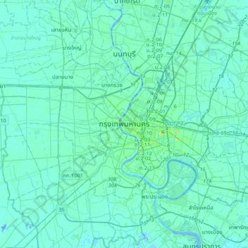
Name: Bangkok topographic map, elevation, terrain.
Location: Bangkok, 10200, Thailand (13.59249 100.33351 13.91249 100.65351)
Average elevation: 4 m
Minimum elevation: -16 m
Maximum elevation: 42 m
Make a donation
Gear up for your next adventure:
As an Amazon Associate, this site earns from qualifying purchases at no extra cost to you.