
Make a donation
Gear up for your next adventure:
As an Amazon Associate, this site earns from qualifying purchases at no extra cost to you.
French Guiana topographic map
Click on the map to display elevation.
Make a donation
Gear up for your next adventure:
As an Amazon Associate, this site earns from qualifying purchases at no extra cost to you.
French Guiana
French Guiana has an equatorial climate predominant. Located within six degrees of the Equator and rising only to modest elevations, French Guiana is hot and oppressively humid all year round. During most of the year, rainfall across the country is heavy due to the presence of the Intertropical Convergence Zone and its powerful thunderstorm cells. In most parts of French Guiana, rainfall is always heavy especially from December to July – typically over 330 millimetres or 13 inches can be expected each month during this period throughout the department. Between August and November, the eastern half experiences a warm dry season with rainfall below 100 millimetres or 3.94 inches and average high temperatures above 30 °C (86 °F) occurring in September and October, causing eastern French Guiana to be classified as a tropical monsoon climate (Köppen Am); Saint-Laurent-du-Maroni in the west has a tropical rainforest climate (Af).
Make a donation
Gear up for your next adventure:
As an Amazon Associate, this site earns from qualifying purchases at no extra cost to you.
About this map
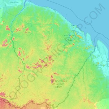
Name: French Guiana topographic map, elevation, terrain.
Location: French Guiana, France (2.11094 -54.60269 5.77695 -51.63461)
Average elevation: 103 m
Minimum elevation: -2 m
Maximum elevation: 791 m
Make a donation
Gear up for your next adventure:
As an Amazon Associate, this site earns from qualifying purchases at no extra cost to you.
Other topographic maps
Click on a map to view its topography, its elevation and its terrain.
Mont Ventoux
France > Provence-Alpes-Côte d'Azur > Vaucluse > Saint-Léger-du-Ventoux
There are two small ski stations on the mountain: "Mont Serein" on the north side, and "Chalet Reynard" on the south. High winds and the modest elevation tend to limit the ski season. Weather conditions are such that the northern slope is often icy, leading to a saying among people of the surrounding region…
Average elevation: 1,557 m
Make a donation
Gear up for your next adventure:
As an Amazon Associate, this site earns from qualifying purchases at no extra cost to you.
Make a donation
Gear up for your next adventure:
As an Amazon Associate, this site earns from qualifying purchases at no extra cost to you.
Curebouteille
France > Nouvelle-Aquitaine > Haute-Vienne > Oradour-sur-Vayres
Average elevation: 312 m
Make a donation
Gear up for your next adventure:
As an Amazon Associate, this site earns from qualifying purchases at no extra cost to you.
Make a donation
Gear up for your next adventure:
As an Amazon Associate, this site earns from qualifying purchases at no extra cost to you.
Ruines du Barrage de Malpasset
France > Provence-Alpes-Côte d'Azur > Var > Fréjus
Average elevation: 118 m
Make a donation
Gear up for your next adventure:
As an Amazon Associate, this site earns from qualifying purchases at no extra cost to you.
Make a donation
Gear up for your next adventure:
As an Amazon Associate, this site earns from qualifying purchases at no extra cost to you.
Make a donation
Gear up for your next adventure:
As an Amazon Associate, this site earns from qualifying purchases at no extra cost to you.
Les Ravineaux
France > Centre-Val de Loire > Indre > Villentrois-Faverolles-en-Berry
Average elevation: 131 m
Make a donation
Gear up for your next adventure:
As an Amazon Associate, this site earns from qualifying purchases at no extra cost to you.
Argentière
France > Auvergne-Rhône-Alpes > Upper Savoy > Chamonix-Mont-Blanc
Argentière (French pronunciation: [aʁʒɑ̃tjɛʁ]) is a picturesque skiing, alpine walking and mountaineering village in the French Alps, part of the commune of Chamonix-Mont-Blanc, at an altitude of 1,252 m (4,108 ft).
Average elevation: 1,674 m
Make a donation
Gear up for your next adventure:
As an Amazon Associate, this site earns from qualifying purchases at no extra cost to you.
Le Tilleul - Antifer
France > Normandy > Seine-Maritime > La Poterie-Cap-d'Antifer
Average elevation: 42 m
Make a donation
Gear up for your next adventure:
As an Amazon Associate, this site earns from qualifying purchases at no extra cost to you.
Make a donation
Gear up for your next adventure:
As an Amazon Associate, this site earns from qualifying purchases at no extra cost to you.
Méribel-Mottaret
France > Auvergne-Rhône-Alpes > Savoy > Les Allues > Méribel-Mottaret
Average elevation: 2,012 m
Collonges
France > Auvergne-Rhône-Alpes > Upper Savoy > Vétraz-Monthoux > Collonges
Average elevation: 477 m
Make a donation
Gear up for your next adventure:
As an Amazon Associate, this site earns from qualifying purchases at no extra cost to you.
Make a donation
Gear up for your next adventure:
As an Amazon Associate, this site earns from qualifying purchases at no extra cost to you.
Make a donation
Gear up for your next adventure:
As an Amazon Associate, this site earns from qualifying purchases at no extra cost to you.
Les Ansaults
France > Centre-Loire Valley > Indre-et-Loire > Artannes-sur-Indre > Les Ansaults
Average elevation: 73 m
Les Clausonnes
France > Provence-Alpes-Côte d'Azur > Maritime Alps > Valbonne > Les Clausonnes
Average elevation: 149 m
Make a donation
Gear up for your next adventure:
As an Amazon Associate, this site earns from qualifying purchases at no extra cost to you.