
Frisco topographic map
Click on the map to display elevation.
Frisco
In 1902, a line of the St. Louis–San Francisco Railway ("the Frisco") was being built through the area, and periodic watering stops were needed along the route for the steam locomotives. The current settlement of Lebanon was on Preston Ridge and was too high in elevation, so the watering stop was placed about 4 miles (6 km) to the west on lower ground. A community grew around this train stop, and some Lebanon residents moved their houses to the new community on logs. The new town was originally named Emerson, but the U.S. Postal Service rejected the name as too similar to another community, Emberson, in Lamar County.
About this map
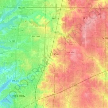
Name: Frisco topographic map, elevation, terrain.
Location: Frisco, Collin County, Texas, United States (33.08150 -96.92279 33.21958 -96.73257)
Average elevation: 201 m
Minimum elevation: 152 m
Maximum elevation: 247 m