
Make a donation
Gear up for your next adventure:
As an Amazon Associate, this site earns from qualifying purchases at no extra cost to you.
Cascais topographic map
Click on the map to display elevation.
Make a donation
Gear up for your next adventure:
As an Amazon Associate, this site earns from qualifying purchases at no extra cost to you.
Cascais
The settlement's prosperity led to its administrative independence from Sintra in 1364. On 7 June 1364, the people of Cascais obtained from King Peter I the elevation of the village to the status of town, necessitating the appointment of local judges and administrators. The townspeople were consequently obligated to pay the Crown 200 pounds of gold annually, as well as bearing the expense of paying the local administrators' salaries. Owing to the regions' wealth, these obligations were easily satisfied. The town and the surrounding lands were owned by a succession of feudal lords, the most famous of whom was João das Regras (died 1404), a lawyer and professor of the University of Lisbon who was involved in the ascension of King John I to power as the first King of the House of Aviz.
Make a donation
Gear up for your next adventure:
As an Amazon Associate, this site earns from qualifying purchases at no extra cost to you.
About this map
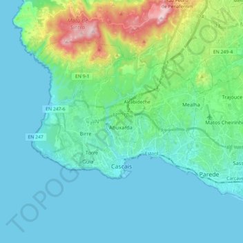
Name: Cascais topographic map, elevation, terrain.
Location: Cascais, Lisbon, Portugal (38.67589 -9.48655 38.76899 -9.30807)
Average elevation: 87 m
Minimum elevation: 0 m
Maximum elevation: 501 m
Make a donation
Gear up for your next adventure:
As an Amazon Associate, this site earns from qualifying purchases at no extra cost to you.
Other topographic maps
Click on a map to view its topography, its elevation and its terrain.