
Dwygyfylchi topographic map
Interactive map
Click on the map to display elevation.
About this map
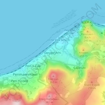
Name: Dwygyfylchi topographic map, elevation, terrain.
Location: Dwygyfylchi, Conwy, Wales, LL34 6PY, United Kingdom (53.25646 -3.92267 53.29646 -3.88267)
Average elevation: 99 m
Minimum elevation: 0 m
Maximum elevation: 410 m
Other topographic maps
Click on a map to view its topography, its elevation and its terrain.
Gwyrch Castle Northern Towers
United Kingdom > Wales > Conwy > Llanddulas > Terfyn
Gwyrch Castle Northern Towers, A547, Terfyn, Llanddulas and Rhyd-y-Foel, Llanddulas, Conwy, Wales, LL22 8EY, United Kingdom
Average elevation: 54 m