
Thank you for supporting this site ❤️
Make a donation
Make a donation
Gear up for your next adventure:
As an Amazon Associate, this site earns from qualifying purchases at no extra cost to you.
Göttingen topographic map
Click on the map to display elevation.
Thank you for supporting this site ❤️
Make a donation
Make a donation
Gear up for your next adventure:
As an Amazon Associate, this site earns from qualifying purchases at no extra cost to you.
About this map
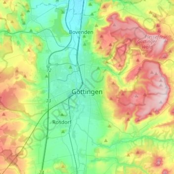
Name: Göttingen topographic map, elevation, terrain.
Location: Göttingen, Landkreis Göttingen, Lower Saxony, Germany (51.48301 9.80013 51.59082 10.05360)
Average elevation: 239 m
Minimum elevation: 128 m
Maximum elevation: 437 m
Thank you for supporting this site ❤️
Make a donation
Make a donation
Gear up for your next adventure:
As an Amazon Associate, this site earns from qualifying purchases at no extra cost to you.