
Make a donation
Gear up for your next adventure:
As an Amazon Associate, this site earns from qualifying purchases at no extra cost to you.
Ranni topographic map
Click on the map to display elevation.
Make a donation
Gear up for your next adventure:
As an Amazon Associate, this site earns from qualifying purchases at no extra cost to you.
Ranni
Ranni is located in southwestern India at 9°23′N 76°49′E / 9.38°N 76.81°E / 9.38; 76.81. It has an average elevation of 131 m (433 ft) above sea level. However, towards the east, the elevation is much higher. The river Pamba flows through Ranni township. According to the 2001 Census of India, Ranni spans a total of 1,004.61 square kilometres (387.88 sq mi). Out of the total area, 708 square kilometres (273.36 sq mi) or 70% are forest.
Make a donation
Gear up for your next adventure:
As an Amazon Associate, this site earns from qualifying purchases at no extra cost to you.
About this map
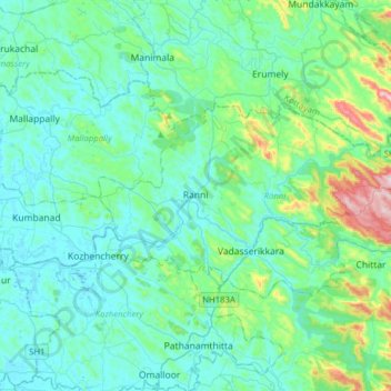
Name: Ranni topographic map, elevation, terrain.
Location: Ranni, Pathanamthitta, Kerala, India (9.30331 76.70632 9.46559 77.02065)
Average elevation: 93 m
Minimum elevation: 2 m
Maximum elevation: 579 m
Make a donation
Gear up for your next adventure:
As an Amazon Associate, this site earns from qualifying purchases at no extra cost to you.