
Make a donation
Gear up for your next adventure:
As an Amazon Associate, this site earns from qualifying purchases at no extra cost to you.
Balanga topographic map
Click on the map to display elevation.
Make a donation
Gear up for your next adventure:
As an Amazon Associate, this site earns from qualifying purchases at no extra cost to you.
About this map
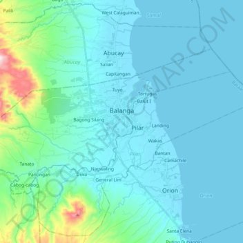
Name: Balanga topographic map, elevation, terrain.
Location: Balanga, Bataan, Central Luzon, 2100, Philippines (14.61880 120.44041 14.72428 120.62245)
Average elevation: 74 m
Minimum elevation: -3 m
Maximum elevation: 633 m
Make a donation
Gear up for your next adventure:
As an Amazon Associate, this site earns from qualifying purchases at no extra cost to you.
Other topographic maps
Click on a map to view its topography, its elevation and its terrain.
Mount Natib
Philippines > Bataan > Morong
Mount Natib is a stratovolcano type of volcano topped by a 6-by-7-kilometre (3.7 by 4.3 mi) acorn-shaped Natib Caldera that is open to the northwest. East of its caldera is the smaller 2-kilometre (1.2 mi) wide Pasukulan Caldera. The highest peak of Mount Natib has an elevation of 1,253 metres (4,111 ft) asl…
Average elevation: 846 m
Make a donation
Gear up for your next adventure:
As an Amazon Associate, this site earns from qualifying purchases at no extra cost to you.