
Thank you for supporting this site ❤️
Make a donation
Make a donation
Gear up for your next adventure:
As an Amazon Associate, this site earns from qualifying purchases at no extra cost to you.
Valmorel topographic map
Click on the map to display elevation.
Thank you for supporting this site ❤️
Make a donation
Make a donation
Gear up for your next adventure:
As an Amazon Associate, this site earns from qualifying purchases at no extra cost to you.
About this map
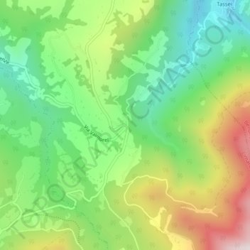
Name: Valmorel topographic map, elevation, terrain.
Location: Valmorel, Limana, Belluno, Veneto, 32020, Italy (46.04429 12.21813 46.06429 12.23813)
Average elevation: 834 m
Minimum elevation: 538 m
Maximum elevation: 1,301 m
Thank you for supporting this site ❤️
Make a donation
Make a donation
Gear up for your next adventure:
As an Amazon Associate, this site earns from qualifying purchases at no extra cost to you.