
Make a donation
Gear up for your next adventure:
As an Amazon Associate, this site earns from qualifying purchases at no extra cost to you.
Nettersheim topographic map
Click on the map to display elevation.
Make a donation
Gear up for your next adventure:
As an Amazon Associate, this site earns from qualifying purchases at no extra cost to you.
About this map
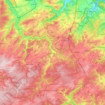
Name: Nettersheim topographic map, elevation, terrain.
Average elevation: 490 m
Minimum elevation: 301 m
Maximum elevation: 606 m
Make a donation
Gear up for your next adventure:
As an Amazon Associate, this site earns from qualifying purchases at no extra cost to you.
Other topographic maps
Click on a map to view its topography, its elevation and its terrain.
Weißer Stein City
Germany > North Rhine-Westphalia > Kreis Euskirchen > Udenbreth
Average elevation: 644 m
Make a donation
Gear up for your next adventure:
As an Amazon Associate, this site earns from qualifying purchases at no extra cost to you.
Make a donation
Gear up for your next adventure:
As an Amazon Associate, this site earns from qualifying purchases at no extra cost to you.
Rodert
Germany > North Rhine-Westphalia > Kreis Euskirchen > Bad Münstereifel
Average elevation: 382 m
Hellenthal
Germany > North Rhine-Westphalia > Kreis Euskirchen > Hellenthal > Hellenthal
Average elevation: 514 m
Make a donation
Gear up for your next adventure:
As an Amazon Associate, this site earns from qualifying purchases at no extra cost to you.