
Make a donation
Gear up for your next adventure:
As an Amazon Associate, this site earns from qualifying purchases at no extra cost to you.
Nansana topographic map
Click on the map to display elevation.
Make a donation
Gear up for your next adventure:
As an Amazon Associate, this site earns from qualifying purchases at no extra cost to you.
Nansana
Nansana is located on the main highway between Kampala and Hoima, the Kampala-Hoima Road. The town is located approximately 12 kilometres (7 mi), by road, north-west of Kampala, Uganda's capital and largest city. This is approximately 8 kilometres (5 mi), by road, south of Wakiso, the location of the district headquarters. The coordinates of the town are 0°21'50.0"N, 32°31'43.0"E (Latitude:0.363889; Longitude:32.528611). Nansana sits at an average elevation of 1,191 metres (3,907 ft), above mean sea level.
Make a donation
Gear up for your next adventure:
As an Amazon Associate, this site earns from qualifying purchases at no extra cost to you.
About this map
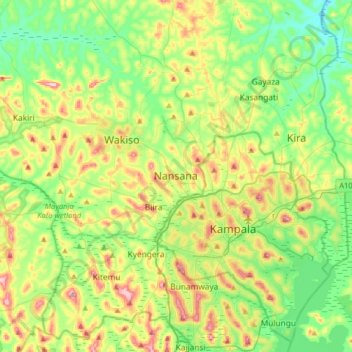
Name: Nansana topographic map, elevation, terrain.
Location: Nansana, Wakiso, Central Region, 7051, Uganda (0.20582 32.36923 0.52582 32.68923)
Average elevation: 1,172 m
Minimum elevation: 1,093 m
Maximum elevation: 1,324 m
Make a donation
Gear up for your next adventure:
As an Amazon Associate, this site earns from qualifying purchases at no extra cost to you.