
Make a donation
Gear up for your next adventure:
As an Amazon Associate, this site earns from qualifying purchases at no extra cost to you.
Makkah Region topographic map
Click on the map to display elevation.
Make a donation
Gear up for your next adventure:
As an Amazon Associate, this site earns from qualifying purchases at no extra cost to you.
Makkah Region
Most of the central and eastern portions of the province are desert, with the Hejaz mountains, which vary in elevation from 600 meters to 2000 meters, separating the relatively flat Nafud desert and coastal plains. Agriculture takes place in the region's many wadis and oases, with the most commonly-grown crops being dates and barley, alongside other vegetables and fruits. The city of Ta'if is famous for its cultivation of the Rosa × damascena flower, simplified as Damask rose and locally known as Ta'if rose.
Make a donation
Gear up for your next adventure:
As an Amazon Associate, this site earns from qualifying purchases at no extra cost to you.
About this map
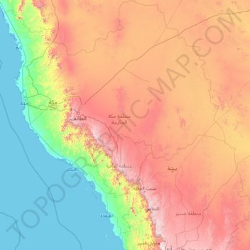
Name: Makkah Region topographic map, elevation, terrain.
Location: Makkah Region, Saudi Arabia (18.28122 38.65977 23.69520 43.83016)
Average elevation: 785 m
Minimum elevation: -4 m
Maximum elevation: 2,910 m
Make a donation
Gear up for your next adventure:
As an Amazon Associate, this site earns from qualifying purchases at no extra cost to you.
Other topographic maps
Click on a map to view its topography, its elevation and its terrain.
Make a donation
Gear up for your next adventure:
As an Amazon Associate, this site earns from qualifying purchases at no extra cost to you.
At Ta'if
Taif (Arabic: اَلطَّائِفُ, romanized: aṭ-Ṭāʾif, lit. 'The circulated or encircled', Hejazi Arabic pronunciation: [atˤˈ tˤaː(j)ɪf]) is a city and governorate in the Mecca Province of Saudi Arabia. Located at an elevation of 1,879 m (6,165 ft) in the slopes of the Hijaz Mountains,…
Average elevation: 1,742 m
Make a donation
Gear up for your next adventure:
As an Amazon Associate, this site earns from qualifying purchases at no extra cost to you.
Neom
On 3 March 2022, Saudi Crown Prince Mohammed bin Salman launched the Trojena project, which will be the first major outdoor skiing destination in the Arabian Peninsula. It will be located about 50 kilometres (31 mi) from the Gulf of Aqaba coast, in the Sarwat Mountains, with elevations ranging from…
Average elevation: 52 m