
Make a donation
Gear up for your next adventure:
As an Amazon Associate, this site earns from qualifying purchases at no extra cost to you.
Remscheid topographic map
Click on the map to display elevation.
Make a donation
Gear up for your next adventure:
As an Amazon Associate, this site earns from qualifying purchases at no extra cost to you.
About this map
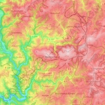
Name: Remscheid topographic map, elevation, terrain.
Location: Remscheid, North Rhine-Westphalia, Germany (51.14229 7.13102 51.22683 7.30932)
Average elevation: 265 m
Minimum elevation: 85 m
Maximum elevation: 381 m
Make a donation
Gear up for your next adventure:
As an Amazon Associate, this site earns from qualifying purchases at no extra cost to you.
Other topographic maps
Click on a map to view its topography, its elevation and its terrain.
Siedlinghausen
Germany > North Rhine-Westphalia > Hochsauerlandkreis > Winterberg
Average elevation: 563 m
Make a donation
Gear up for your next adventure:
As an Amazon Associate, this site earns from qualifying purchases at no extra cost to you.