
Thank you for supporting this site ❤️
Make a donation
Make a donation
Gear up for your next adventure:
As an Amazon Associate, this site earns from qualifying purchases at no extra cost to you.
Sanandaj topographic map
Click on the map to display elevation.
Thank you for supporting this site ❤️
Make a donation
Make a donation
Gear up for your next adventure:
As an Amazon Associate, this site earns from qualifying purchases at no extra cost to you.
About this map
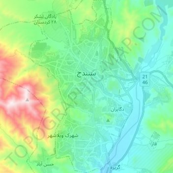
Name: Sanandaj topographic map, elevation, terrain.
Location: Sanandaj, بخش مرکزی, Sanandaj County, Kurdistan Province, Iran (35.25396 46.95646 35.35515 47.03485)
Average elevation: 1,608 m
Minimum elevation: 1,372 m
Maximum elevation: 2,353 m
Thank you for supporting this site ❤️
Make a donation
Make a donation
Gear up for your next adventure:
As an Amazon Associate, this site earns from qualifying purchases at no extra cost to you.