
Make a donation
Gear up for your next adventure:
As an Amazon Associate, this site earns from qualifying purchases at no extra cost to you.
Riedlingen topographic map
Click on the map to display elevation.
Make a donation
Gear up for your next adventure:
As an Amazon Associate, this site earns from qualifying purchases at no extra cost to you.
About this map
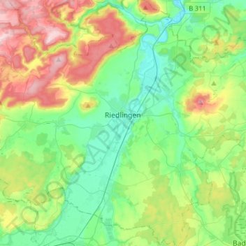
Name: Riedlingen topographic map, elevation, terrain.
Average elevation: 598 m
Minimum elevation: 513 m
Maximum elevation: 781 m
Make a donation
Gear up for your next adventure:
As an Amazon Associate, this site earns from qualifying purchases at no extra cost to you.
Other topographic maps
Click on a map to view its topography, its elevation and its terrain.
Kleinwinnaden
Germany > Baden-Württemberg > Landkreis Biberach > Bad Schussenried
Average elevation: 584 m
Burg
Germany > Baden-Württemberg > Landkreis Biberach > Bad Schussenried > Otterswang
Average elevation: 611 m
Bergerhausen
Germany > Baden-Württemberg > Landkreis Biberach > Biberach an der Riß
Average elevation: 579 m
Make a donation
Gear up for your next adventure:
As an Amazon Associate, this site earns from qualifying purchases at no extra cost to you.