
Make a donation
Gear up for your next adventure:
As an Amazon Associate, this site earns from qualifying purchases at no extra cost to you.
Santa Fe topographic map
Click on the map to display elevation.
Make a donation
Gear up for your next adventure:
As an Amazon Associate, this site earns from qualifying purchases at no extra cost to you.
Santa Fe
Santa Fe (/ˌsæntə ˈfeɪ, ˈsæntə ˌfeɪ/ SAN-tə FAY, - fay; Spanish: [santa ˈfe]; Spanish for 'Holy Faith') is the capital city of the U.S. state of New Mexico. It is the fourth-most populous city in the state with a population of 87,505 as of the 2020 census, while the Santa Fe metropolitan area has an estimated 158,000 people. The greater Albuquerque–Santa Fe–Los Alamos combined statistical area includes eight counties in north-central New Mexico with 1.16 million residents. The county seat of Santa Fe County, Santa Fe is situated at the foothills of the Sangre de Cristo Mountains at the highest altitude of any U.S. state capital, with an elevation of 6,998 feet (2,133 m).
Make a donation
Gear up for your next adventure:
As an Amazon Associate, this site earns from qualifying purchases at no extra cost to you.
About this map
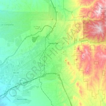
Name: Santa Fe topographic map, elevation, terrain.
Location: Santa Fe, Santa Fe County, New Mexico, United States (35.58804 -106.11216 35.75462 -105.89418)
Average elevation: 2,221 m
Minimum elevation: 1,915 m
Maximum elevation: 2,862 m
Make a donation
Gear up for your next adventure:
As an Amazon Associate, this site earns from qualifying purchases at no extra cost to you.
Other topographic maps
Click on a map to view its topography, its elevation and its terrain.
Make a donation
Gear up for your next adventure:
As an Amazon Associate, this site earns from qualifying purchases at no extra cost to you.
Make a donation
Gear up for your next adventure:
As an Amazon Associate, this site earns from qualifying purchases at no extra cost to you.