
Make a donation
Gear up for your next adventure:
As an Amazon Associate, this site earns from qualifying purchases at no extra cost to you.
Mestia topographic map
Click on the map to display elevation.
Make a donation
Gear up for your next adventure:
As an Amazon Associate, this site earns from qualifying purchases at no extra cost to you.
Mestia
Mestia (Georgian: მესტია IPA: [mestʼia]) is a highland townlet (daba) in northwest Georgia, at an elevation of 1,500 metres (4,921 feet) in the Caucasus Mountains.
Make a donation
Gear up for your next adventure:
As an Amazon Associate, this site earns from qualifying purchases at no extra cost to you.
About this map
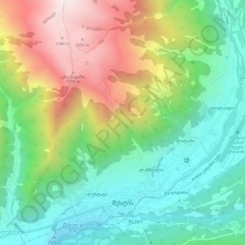
Name: Mestia topographic map, elevation, terrain.
Location: Mestia, Mestia Municipality, Samegrelo-Upper Svaneti, Georgia (43.03758 42.70463 43.07569 42.75821)
Average elevation: 1,749 m
Minimum elevation: 1,338 m
Maximum elevation: 2,461 m
Make a donation
Gear up for your next adventure:
As an Amazon Associate, this site earns from qualifying purchases at no extra cost to you.