
Thank you for supporting this site ❤️
Make a donation
Make a donation
Gear up for your next adventure:
As an Amazon Associate, this site earns from qualifying purchases at no extra cost to you.
Taylor topographic map
Click on the map to display elevation.
Thank you for supporting this site ❤️
Make a donation
Make a donation
Gear up for your next adventure:
As an Amazon Associate, this site earns from qualifying purchases at no extra cost to you.
About this map
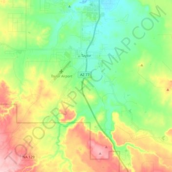
Name: Taylor topographic map, elevation, terrain.
Location: Taylor, Navajo County, Arizona, 85939, United States (34.39632 -110.17609 34.48431 -110.01054)
Average elevation: 1,766 m
Minimum elevation: 1,699 m
Maximum elevation: 1,876 m
Thank you for supporting this site ❤️
Make a donation
Make a donation
Gear up for your next adventure:
As an Amazon Associate, this site earns from qualifying purchases at no extra cost to you.