
Make a donation
Gear up for your next adventure:
As an Amazon Associate, this site earns from qualifying purchases at no extra cost to you.
Marina topographic map
Click on the map to display elevation.
Make a donation
Gear up for your next adventure:
As an Amazon Associate, this site earns from qualifying purchases at no extra cost to you.
Marina
Marina is a city in Monterey County, California, United States. The United States Census Bureau estimated its 2019 population at 22,781. Marina is located along the central coast of California, 8 miles (13 km) west of Salinas, and 8 miles (13 km) north of Monterey. Marina is on California State Route 1 between Monterey and Santa Cruz. Marina is at an elevation of 43 feet (13 m). Marina was incorporated in 1975 and is the newest city on the Monterey Peninsula. The city includes part of the California State University, Monterey Bay campus, UC Santa Cruz UC MBEST center, and the Veterans Transition Center (VTC). In 2012, Marina was named one of the 100 Best Communities for Young People by America's Promise Alliance. The Fort Ord Station Veterinary Hospital, built in 1941 to provide healthcare for U.S. Army horses and mules, was listed on the National Register of Historic Places in 2014.
Make a donation
Gear up for your next adventure:
As an Amazon Associate, this site earns from qualifying purchases at no extra cost to you.
About this map
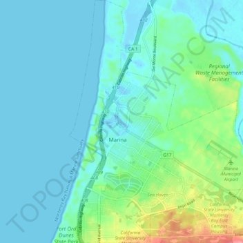
Name: Marina topographic map, elevation, terrain.
Location: Marina, Monterey County, California, 93933, United States (36.65283 -121.82075 36.72698 -121.74505)
Average elevation: 17 m
Minimum elevation: -3 m
Maximum elevation: 94 m
Make a donation
Gear up for your next adventure:
As an Amazon Associate, this site earns from qualifying purchases at no extra cost to you.