
Winchester topographic map
Interactive map
Click on the map to display elevation.
About this map
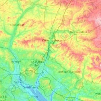
Name: Winchester topographic map, elevation, terrain.
Location: Winchester, Hampshire, England, United Kingdom (50.85512 -1.45651 51.19700 -1.03391)
Average elevation: 73 m
Minimum elevation: -3 m
Maximum elevation: 230 m
Other topographic maps
Click on a map to view its topography, its elevation and its terrain.
Itchen Abbas
United Kingdom > England > Hampshire > Winchester
Itchen Abbas, Winchester, Hampshire, England, SO21 1DJ, United Kingdom
Average elevation: 81 m
Medstead
United Kingdom > England > Hampshire > East Hampshire
Medstead, East Hampshire, Hampshire, England, United Kingdom
Average elevation: 185 m
Horndean
United Kingdom > England > Hampshire > East Hampshire
Horndean, East Hampshire, Hampshire, England, United Kingdom
Average elevation: 92 m
West Meon
United Kingdom > England > Hampshire > Winchester
West Meon, Winchester, Hampshire, England, United Kingdom
Average elevation: 124 m