
Tébessa topographic map
Interactive map
Click on the map to display elevation.
About this map
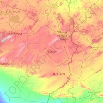
Name: Tébessa topographic map, elevation, terrain.
Location: Tébessa, Algeria (34.24376 7.22751 36.00378 8.47653)
Average elevation: 757 m
Minimum elevation: -21 m
Maximum elevation: 2,130 m
Other topographic maps
Click on a map to view its topography, its elevation and its terrain.
Algiers
Algeria > Algiers > Sidi M'Hamed District > Alger-Centre
Algiers was a walled city from the time of the deys until the close of the 19th century. The French, after their occupation of the city (1830), built a rampart, parapet and ditch, with two terminal forts, Bab Azoun باب عزون to the south and Bab-el-Oued اد to the north. The forts and part of the…
Average elevation: 45 m