
Thank you for supporting this site ❤️
Make a donation
Make a donation
Gear up for your next adventure:
As an Amazon Associate, this site earns from qualifying purchases at no extra cost to you.
Borrowdale topographic map
Click on the map to display elevation.
Thank you for supporting this site ❤️
Make a donation
Make a donation
Gear up for your next adventure:
As an Amazon Associate, this site earns from qualifying purchases at no extra cost to you.
About this map
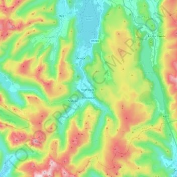
Name: Borrowdale topographic map, elevation, terrain.
Location: Borrowdale, Allerdale, Cumbria, England, United Kingdom (54.45410 -3.21932 54.59275 -3.08723)
Average elevation: 384 m
Minimum elevation: 62 m
Maximum elevation: 969 m
Thank you for supporting this site ❤️
Make a donation
Make a donation
Gear up for your next adventure:
As an Amazon Associate, this site earns from qualifying purchases at no extra cost to you.