
Thank you for supporting this site ❤️
Make a donation
Make a donation
Gear up for your next adventure:
As an Amazon Associate, this site earns from qualifying purchases at no extra cost to you.
Montecristo topographic map
Click on the map to display elevation.
Thank you for supporting this site ❤️
Make a donation
Make a donation
Gear up for your next adventure:
As an Amazon Associate, this site earns from qualifying purchases at no extra cost to you.
About this map
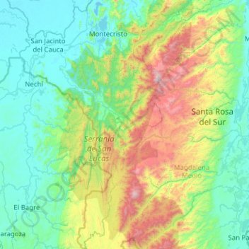
Name: Montecristo topographic map, elevation, terrain.
Location: Montecristo, Mojana, Bolívar, RAP Caribe, Colombia (7.43175 -74.69581 8.43013 -74.25547)
Average elevation: 457 m
Minimum elevation: 17 m
Maximum elevation: 2,186 m
Thank you for supporting this site ❤️
Make a donation
Make a donation
Gear up for your next adventure:
As an Amazon Associate, this site earns from qualifying purchases at no extra cost to you.