
Fairy Castle topographic map
Interactive map
Click on the map to display elevation.
About this map
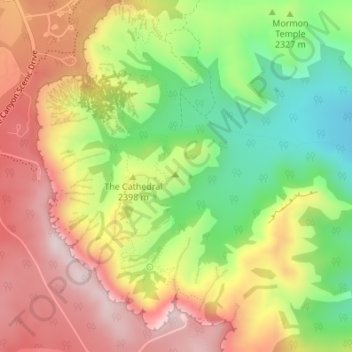
Name: Fairy Castle topographic map, elevation, terrain.
Location: Fairy Castle, Garfield County, Utah, United States (37.61481 -112.15742 37.61491 -112.15732)
Average elevation: 2,354 m
Minimum elevation: 2,148 m
Maximum elevation: 2,551 m
Other topographic maps
Click on a map to view its topography, its elevation and its terrain.
Bryce Canyon
United States > Utah > Garfield County > Tropic
Bryce Canyon, Tropic, Garfield County, Utah, United States
Average elevation: 2,247 m
Escalante
United States > Utah > Garfield County
Escalante, Garfield County, Utah, 84726, United States
Average elevation: 1,781 m
Capitol Reef National Park
United States > Utah > Garfield County
Capitol Reef National Park, Garfield County, Utah, United States
Average elevation: 1,963 m