
Thank you for supporting this site ❤️
Make a donation
Make a donation
Gear up for your next adventure:
As an Amazon Associate, this site earns from qualifying purchases at no extra cost to you.
Túquerres topographic map
Click on the map to display elevation.
Thank you for supporting this site ❤️
Make a donation
Make a donation
Gear up for your next adventure:
As an Amazon Associate, this site earns from qualifying purchases at no extra cost to you.
About this map
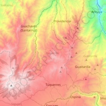
Name: Túquerres topographic map, elevation, terrain.
Location: Túquerres, La Sabana, Nariño, Colombia (1.03693 -77.70235 1.28930 -77.55907)
Average elevation: 2,735 m
Minimum elevation: 1,008 m
Maximum elevation: 4,034 m
Thank you for supporting this site ❤️
Make a donation
Make a donation
Gear up for your next adventure:
As an Amazon Associate, this site earns from qualifying purchases at no extra cost to you.