
Make a donation
Gear up for your next adventure:
As an Amazon Associate, this site earns from qualifying purchases at no extra cost to you.
Atibaia topographic map
Click on the map to display elevation.
Make a donation
Gear up for your next adventure:
As an Amazon Associate, this site earns from qualifying purchases at no extra cost to you.
Atibaia
Atibaia has 478 square kilometers of area, 40% of this area is urbanized. The average altitude is 800 meters.
Make a donation
Gear up for your next adventure:
As an Amazon Associate, this site earns from qualifying purchases at no extra cost to you.
About this map
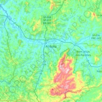
Name: Atibaia topographic map, elevation, terrain.
Average elevation: 861 m
Minimum elevation: 731 m
Maximum elevation: 1,388 m
Make a donation
Gear up for your next adventure:
As an Amazon Associate, this site earns from qualifying purchases at no extra cost to you.
Other topographic maps
Click on a map to view its topography, its elevation and its terrain.
Jardim Copacabana
Brazil > São Paulo > Região Metropolitana de São Paulo > São Paulo
Average elevation: 792 m