
Make a donation
Gear up for your next adventure:
As an Amazon Associate, this site earns from qualifying purchases at no extra cost to you.
Feldkirchen topographic map
Click on the map to display elevation.
Make a donation
Gear up for your next adventure:
As an Amazon Associate, this site earns from qualifying purchases at no extra cost to you.
About this map
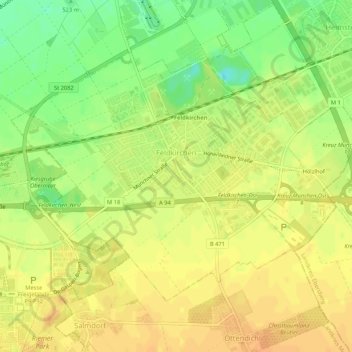
Name: Feldkirchen topographic map, elevation, terrain.
Location: Feldkirchen, Landkreis München, Bavaria, 85622, Germany (48.13266 11.70505 48.15770 11.75798)
Average elevation: 525 m
Minimum elevation: 505 m
Maximum elevation: 536 m
Make a donation
Gear up for your next adventure:
As an Amazon Associate, this site earns from qualifying purchases at no extra cost to you.
Other topographic maps
Click on a map to view its topography, its elevation and its terrain.
Deisenhofen
Germany > Bavaria > Landkreis München > Oberhaching > Deisenhofen
Average elevation: 592 m
Feldkirchen
Germany > Bavaria > Landkreis München > Feldkirchen > Feldkirchen
Average elevation: 524 m